Spherical Cap Complete Bouguer Correction – Processing Methodology
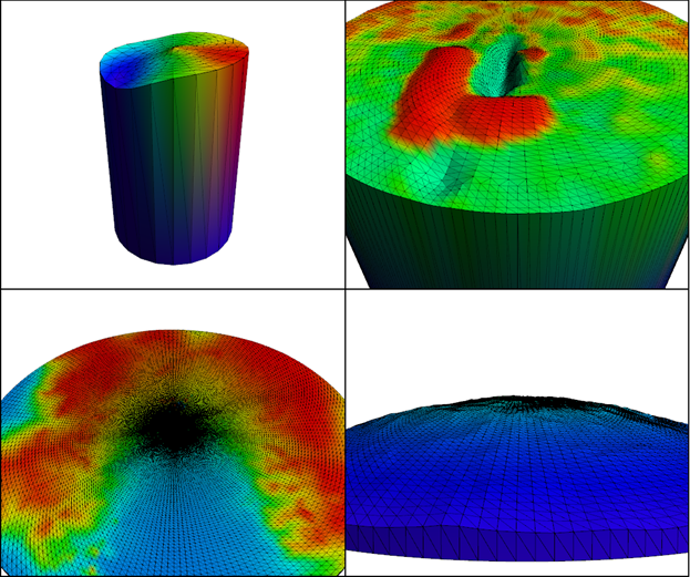
In this article I discuss the Spherical Cap Complete Bouguer Correction for gravity observations and my processing methodology for computing these corrections.

In this article I discuss the Spherical Cap Complete Bouguer Correction for gravity observations and my processing methodology for computing these corrections.

Combining multiple raster datasets with MapInfo virtual rasters and MapInfo raster rendering algorithm technology, I have prepared a new visualisation of global terrain and topography that mimics the kind of color scheme used in an atlas.
MapInfo Pro can render huge rasters and promises to do so in constant time at any scale. But, if you try it, you might run into problems. In this article I want to share some tips for achieving high quality and high-performance rendering of huge rasters.
In this article I compare two publicly available global scale DEM rasters – CGIAR DEM vs MERIT DEM.

The MERIT DEM is a global scale terrain DEM at 3 arcsecond resolution with coverage from 60 degrees South to 90 degrees North. So, it excludes Antarctica but includes the Northern Latitudes, which is a considerable improvement over similar DEM’s derived from Shuttle Radar Topography Mission (SRTM) data. It was developed by Dai Yamazaki at the University of Tokyo.
When you convert a raster to MRR format, and then convert the MRR back to a raster in the original format, the size of the raster almost always changes. Why is this and what is going on behind the scenes? In this article I explain some of the concepts around raster size in an MRR format raster, exploring concepts like Grid Size, Cell Range, Valid Cell Range and Extant Tile Boundary. I also explore the issues around the file size of an MRR format raster, and what properties affect file size.